

Every fall and winter, the North Atlantic Ocean seems to wake up. It’s like a bear coming out of hibernation. But why are these storms, generating massive swells, so regularly and cyclically present during the cold season?
It all starts in the American continent.
The famous North Atlantic storms are mainly caused by the clash of two meteorological phenomena: the Gulf Stream and its warm ocean water currents, and the northern polar jet stream with its cold continental air.
The interaction between these two opposite worlds fuels mighty low-pressure systems, which then inevitably generate massive groundswells.
In short, the seasonal cooling of land, the warmth of the Gulf Stream, and the active winter jet stream combine to turn the North Atlantic into a near-constant wave machine.
But first, let’s learn more about each weather actor to understand the North Atlantic storm showdown during the autumn and winter months.
It’s all part of the bigger picture that is meteorology and weather on planet Earth.

Actor One: The Gulf Stream
The Gulf Stream is a warm, fast-moving current of seawater that flows northward along the east coast of the United States before bending across the North Atlantic toward Europe near 36° N latitude.
It starts in the Gulf of Mexico, where tropical heat warms the ocean to bathtub-like temperatures.
As that warm water exits through the Florida Straits, it becomes the Gulf Stream, a current so strong that it moves about 100 times more water per second than all the world’s rivers combined.
As it flows north, the Gulf Stream hugs the US coastline up to about Cape Hatteras, North Carolina, then swings northeast into open ocean.
There, it meets colder waters from the north and begins to widen and slow down.
Because the Gulf Stream carries so much heat, it acts like a massive conveyor belt of warmth, transferring tropical energy into the North Atlantic and even helping to keep Western Europe’s climate milder than other regions at the same latitude.
For example, cities like London or Paris stay far warmer in winter than places such as Newfoundland, Canada, which lies at a similar distance from the equator but lacks the Gulf Stream’s warming influence.
Now, imagine if these two capitals had the climate of Newfoundland.
The Gulf Stream is also part of a larger global system called the Atlantic Meridional Overturning Circulation (AMOC).
After releasing its heat to the atmosphere, the Gulf Stream’s water cools, becomes denser, and sinks in the far North Atlantic, helping drive deep ocean currents that circulate around the globe.

Actor Two: The Jet Stream
Now that we’ve learned about the Gulf Stream’s powerful and warm water current, it’s time to fly with the jet stream.
The jet stream is a fast-moving “river” of air high in the atmosphere, roughly 5 to 7 miles (8 to 12 kilometers) above the surface.
It forms where cold polar air meets warmer tropical air, creating a steep temperature contrast that drives powerful winds.
In the Northern Hemisphere, the main one that affects the North Atlantic is the polar front jet stream, which can blow at speeds over 200 miles per hour (320 kilometers per hour).
During autumn and winter, the temperature difference between the poles and the tropics becomes stronger, and the jet stream intensifies and shifts southward.
As it strengthens, it acts like a conveyor belt for weather systems, guiding and energizing low-pressure storms that spin up over the Atlantic.
The jet stream doesn’t flow in a straight line. Instead, it meanders like a river, creating dips (troughs) and ridges that determine where storms will form and move.
When the jet stream dips over North America and rises again over the Atlantic, it can help storms “bomb out,” meaning they rapidly deepen and generate powerful winds and swells.
The position and strength of the jet stream explain why the North Atlantic is so active in autumn and winter.
It basically channels a steady train of storm systems eastward toward Europe, producing the big, regular swells that surfers and meteorologists track all season long.

1+1 = Storm
A key reason late-year storms in the Northern Hemisphere are fierce is the huge temperature difference between sea and land.
In winter, North America and Europe cool down quickly, but the ocean stays warm longer.
For example, the Gulf Stream hugs the East Coast, keeping Atlantic waters unusually warm next to icy air.
As a result, the imbalance fuels storm growth.
For instance, the temperature difference between the cold land mass and the warmer ocean generates the famous Nor’easter cyclones on the US East Coast.
It’s actually pretty simple to understand. Nature is always trying to balance heat.
So, when warm water meets cold air, a storm drinks that energy, picking up moisture from the ocean and spinning it into wind.
Weaker storms just bring rain, but the biggest storms combine cold air and Gulf Stream warmth to build “virtual hurricanes of winter.”
Meteorologist John Davitt notes that these storms have “tropical-like strength” and are “well-known for churning up big waves along the Northeast”.
In fact, Davitt says, “The surf from these systems is often big enough to lead to destructive coastal flooding.”
: difference in atmospheric pressure sends storms in slightly different directions | Illustration: NOAA")
A Subtle Oscillation With Massive Consequences
Another reason for regular winter swells is the behavior of the jet stream and the North Atlantic Oscillation (NAO), which is the difference in atmospheric pressure at sea level between the Icelandic Low and the Azores High.
As we’ve seen above, the jet stream is a high-altitude wind band that steers storms and intensifies them.
In winter, the jet stream plunges south and speeds up as the Arctic chill strengthens. Consequently, it also pushes storm centers over the ocean.
In a positive NAO phase, a strong Atlantic jet runs more to the north, giving northern Europe even more storms and big waves.
In a negative NAO, the jet shifts south, sending storms toward Spain and Portugal.
Either way, the Atlantic coasts – from Iceland to Portugal – get hit by swells when storm tracks run west-to-east under the winter jet stream.
One veteran sailor observed that “gale frequency goes up dramatically” north of 45° N once September hits.
Season charts show very high storm odds after September.
Moreover, some autumn storms “bomb out” – a rapid deepening of low pressure – sending winds howling.
Mariners have reported 20-30-foot seas as routine in these bomb cyclones.
In one case, a 1995 fall storm – Hurricane Luis – even produced a nearly 100-foot rogue wave hitting the Queen Elizabeth II cruise liner.

Powered by a Storm: From Ripple to Record-Breaking Waves
So how do storms turn into surf? By now, you might have figured out why.
The answer lies in the fundamentals of wave formation: as strong winds blow over water, they transfer energy to the surface.
At first, tiny ripples form, then larger wind-waves, and finally longer swells roll out of the storm. The largest groundswells come from storm winds blowing over an uninterrupted long distance called fetch.
In a North Atlantic storm, fetch can stretch for hundreds of miles in one direction. That is why NOAA notes that “wave height is affected by wind speed, wind duration, and fetch.”
Winter storms often combine high winds (50-80+ knots), sustained for a day or more over a huge fetch. And that is exactly the recipe for giant swells.
Once formed, swells radiate away from the storm center in all directions. They travel fast and far with little loss of energy, because the ocean is deep and cold.
For example, a 15-second swell moves about 560 miles (900 kilometers) in 24 hours.
A storm off Newfoundland can send high-energy, 15-20 second groundswells all the way to Europe in a week.
In fact, NASA reports that even hurricanes far out at sea (like Humberto in 2025) generated XXL surf in the Caribbean, Bermuda, and up the US East Coast.
Humberto’s swells caused high surf conditions from the Bahamas to New York, with forecasters warning of large swells and rip currents reaching Mid-Atlantic beaches.
In short, North Atlantic storms act like giant wave-makers. They run long fetches and pump out energy for days.
When swells arrive at the shore, their height depends on offshore depth and continental shelf shape.
But even ordinary coastlines see much higher waves in winter.
Hurricanes Becoming Winter Storms
Here’s another curious fact: some Atlantic hurricanes (June 1 through November 1) live on as winter swells after losing tropical shape.
In late fall, hurricanes move north and hit colder water.
As NOAA explains, when tropical storms shift into the mid-latitudes, they can undergo extratropical transition between 30° N and 40° N latitude.
In other words, they lose their warm core but often merge with other weather fronts and jet stream energy.
NOAA’s Hurricane Research Division warns that during extratropical transition, “these systems may produce intense rainfall, large waves, and hurricane-force winds.”
In other words, a storm like Sandy (2012) or Ophelia (2017) can fade as a hurricane but grow as a monster North Atlantic cyclone.
In recent years, big hurricanes have rammed into colder seas and become winter-like storms off Greenland or Europe.
Their immense wind field can hammer the North Atlantic with swells long after the storm was “officially” a hurricane.
For example, 2017’s ex-hurricane Ophelia crossed near Ireland and famously sent 30-foot (nine-meter) waves to British surf spots.
Because of this, autumn’s active hurricane season can bleed into winter surf and add extra firepower to the normal storms.

Swells Across the North Atlantic Basin
The outcome of all this storm-making is pretty impressive.
Every autumn and winter, a near-constant conveyor of swell heads for coasts up and down the North Atlantic.
On the US East Coast, surfers and beachgoers see waves from Maine all the way down to Florida, though Florida’s Gulf of Mexico side is sheltered.
Along these coasts, the biggest swells often come from Nor’easters and strong cold fronts.
From Georgia northward, autumn/winter swells regularly reach head-high and beyond, with long periods, that is, 10-20 plus seconds.
Across the ocean, Western Europe’s Atlantic shores are hammered too. Ireland, the UK, France, Spain, and Portugal sit directly in the path of North Atlantic swells.
Each strong storm near Iceland or the Labrador Sea flings swells toward Europe.
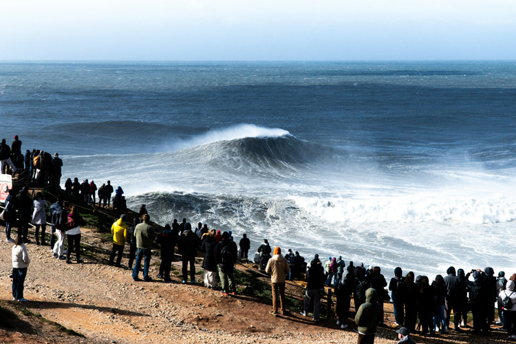
Portugal’s Nazaré has become famous for the freakish 80-foot waves generated in winter by huge North Atlantic storms and amplified by its local undersea canyon.
But even usual spots like Hossegor (France), Bundoran (Ireland), or Devon (southwest England) sometimes owe their prime surf to these storms.
Locals say autumn to early spring is surfing’s high season and rightly so: historically, about 75-80 percent of Europe’s largest swells arrive from October through April.
 vs. Top 40 North Atlantic Storms (1991-2024) | Illustration: ESA")
Records and Rising Trends
But it’s not just surfers who have noticed the strength of the North Atlantic during winter. Data from buoy networks confirm record-breaking waves in recent winters.
The UK Met Office reports that in winter 2007/2008, its buoys measured two waves of 18 meters (nearly 60 feet), the highest ever recorded by their network.
In fact, they say severe wave events seem to be occurring more often in the northeast Atlantic.
Independent studies of global wave records also find that Northern Hemisphere winter wave heights have climbed over the last few decades, partly due to changing climate patterns and stronger storms.
Measurements from the Surface Water and Ocean Topography (SWOT) mission have revealed that the between December 21, 2024, January 6, 2025, observed open-ocean waves reached nearly 65 feet (20 meters).
Words by Luís MP | Founder of SurferToday.com
Leave a Reply