

It’s one of the strongest low-pressure systems to hit Portugal in years. Depression Ingrid prepares to slam the southwestern European nation with massive swells hitting the coastline. Nazaré is on hold.
A Portuguese meteorologist even called it the “Lady Storm” that will affect mainland Portugal through January 25, 2026.
It’s a rare weather phenomenon that reminds us of the “Black Swell” coined by SurferToday in 2014, even though XXL North Atlantic winter swells are common.
The Portuguese Institute of the Sea and Atmosphere (IPMA) underlines that the severe storm, which combines several risk factors at once, will bring big waves, strong, gusty winds, persistent rain, and snowfall in higher areas.
And snow is something rare in Portugal.
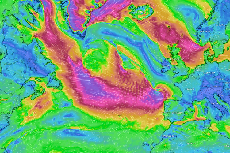
The low pressure is coming from Newfoundland/Labrador, moving in a straight line toward the Portuguese coast. Nazaré’s underwater canyon is expected to boost the groundswell formed thousands of miles away.
Thursday 22: fronts move in, sea begins to build
By Thursday afternoon, the front linked to Ingrid will reach Portugal.
IPMA forecasts periods of rain that may become heavy, and these will turn into showers from the evening onward, sometimes with hail or thunder.
At the same time, the wind will start to strengthen from the west, especially along the coast.
Gusts of about 37-43 miles per hour (70-80 kilometers per hour) at sea level and 43-62 miles per hour (80-100 kilometers per hour) inland in higher ground are possible later on Thursday.
The swell begins to grow on this day as wind and the storm’s energy transfer into the ocean. Giant waves are expected at Nazaré’s Praia do Norte, for instance, with swell direction mainly from the northwest.
Friday 23 and Saturday 24: big waves and harsh ocean conditions
From January 23 through Sunday, the ocean conditions will become increasingly wild.
IPMA forecasts significant wave heights of 20 to 26 feet (6 to 8 meters) off the west coast from northwest swells.
Locally, maximum waves could reach 50 feet (15 meters) in the biggest sets.
For surfers, a northwest swell this large means powerful surf, strong currents, and big shorebreaks.
We’re not talking about just choppy water. It’s actually a storm swell.
Warnings for strong sea agitation are already in effect in multiple coastal districts and will escalate through Thursday into orange alerts as Ingrid’s peak arrives.
Wind, rain, and snow across the country
The wind through this period will be sustained and gusty.
With westerly flow strengthening late Thursday, expect breezes that make travel more difficult in exposed areas and add wind chop to the ocean surface.
Rain will persist from Thursday into the weekend. Heavy downpours on Friday could lead to localized flooding or fast-rising water in rivers and low-lying zones.
Snow is also part of this storm. Higher terrain in northern and central Portugal could see significant snowfall.
IPMA notes snow falling above roughly 2,625 feet (800 meters) altitude, with the snow level possibly dropping to 1,970 feet (600 meters) at times between Friday evening and Saturday morning.
Accumulations in mountain areas could reach about 10 inches (25 centimeters).
Words by Luís MP | Founder of SurferToday.com
Leave a Reply