

Imagine a hidden whip of wind inside a big storm.
High above the ground, cold air suddenly dives downward and slams into the surface, creating a narrow strip of violent winds that can hit much harder than the rest of the storm, like the sharp sting at the end of a scorpion’s tail.
That’s a simple written visual image of what a sting jet is.
So, in other words, a sting jet is a narrow, fast-moving stream of wind that forms within certain large storm systems known as extratropical cyclones.
These storms are the typical low-pressure weather systems that bring rain, wind, and clouds across the mid-latitudes – places like western Europe and the North Atlantic.
A sting jet is not the main wind of the storm, though.
It is a smaller burst of very strong winds that reaches the ground from higher in the atmosphere.
Meteorologists describe it as a mesoscale airstream, meaning it is smaller than the storm itself, often no more than about 30-50 miles (50-80 kilometers) wide, and it usually lasts three or four hours at most.
All these characteristics make it hard to spot in early forecasts. Therefore, the potential consequences can be unpredictable.

How sting jets form
Let’s see. Sting jets develop in some cyclones that follow a specific pattern of evolution.
Storms have zones of warm and cold air that swirl together.
In many cyclones, powerful conveyor belts of air – both warm rising air and cold sinking air – feed the storm’s energy.
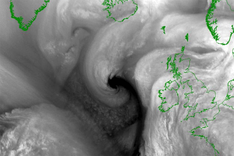
In storms capable of producing a sting jet, the structure changes in a way that opens a gap between fronts and creates a “back-bent” shape in the cloudy wrap around the low-pressure center.
Inside that curled cloud pattern, a region of cool, dry air descends from several kilometers above the ground.
As rain or snow falls into this air and evaporates, the air cools further. Cooler air is denser and falls faster, accelerating like a rollercoaster drop.
That descending airstream carries strong winds downward, concentrating them into a narrow jet that hits the surface.
The shape of the cloud feature on satellite images – curving like the tail of a scorpion – inspired the name “sting jet.”

Where and when they happen
Sting jets were first recognized by weather scientists during the Great Storm of October 1987 over the UK and northern France, when hurricane-force gusts caused widespread tree damage and destruction.
That event led researchers to formally identify the meteorological mechanism in the early 2000s.
Research has shown that sting jets most often occur in powerful cyclones over the North Atlantic, especially during autumn and winter.
The same ones that produce the famous XXL swells that hit western Europe hard and lit up big wave surfing spots like Nazaré’s Praia do Norte.
In that oceanic region, 30-40 percent of the strongest storms appear to produce sting jets or conditions very close to them. That is, roughly a third.
They tend to occur where strong temperature contrasts and moisture provide the right conditions for rapidly intensifying low-pressure systems.
However, scientists now believe sting jets may exist in major storms over other ocean basins, too.
A global study of historical cyclone data has identified signs of similar features in the North Pacific and over the Southern Ocean, even if they have been studied less.
Also, studies suggest such features are more common in the Northern Hemisphere than in the Southern Hemisphere.
How strong are sting jets?
The strongest winds from sting jets can exceed 100 miles per hour (about 160 kilometers per hour) near the surface.
In some recorded cases, winds in these jets have reached even higher speeds during powerful storms.
These intense gusts may occur in a very localized corridor, so a town in the path of a sting jet can suffer extreme winds while areas just tens of miles away experience much weaker winds.
The weather phenomenon can also increase wave heights locally because it brings a burst of very strong surface winds over the ocean.
Why early signs are hard to spot
Meteorologists can identify broad storm systems and their fronts well in advance, but sting jets are smaller by comparison and develop at mid-levels of the atmosphere.
Many global forecast models do not have enough detail to pick them out clearly.
Forecasters look for telltale signs in high-resolution models and on satellite images: a hook-shaped cloud structure and areas of dry air intruding into the storm.
Forecast teams also study atmospheric instability and mid-tropospheric conditions that favor descending air.
All clues help forecasters issue warnings when a sting jet might form, but predicting the exact location and strength remains challenging.
Effects on people and infrastructure
When a sting jet strikes, it can bring sudden, destructive wind gusts that damage buildings, uproot trees, and disrupt power and transport.
Because the intense winds occur in narrow bands, emergency services may be stretched responding to multiple affected communities in a storm’s wake.
As we’ve seen above, sting jets are most frequently reported in Europe and the North Atlantic region, but as global research expands, scientists are watching whether similar features occur in strong mid-latitude storms elsewhere.
Meanwhile, atmospheric scientists continue refining tools for detection and forecasting.
New satellite technology and increasingly powerful weather models help improve warnings, but the tiny scale and short duration of sting jets mean they will likely remain one of weather forecasting’s toughest challenges for now.
Words by Luís MP | Founder of SurferToday.com
Leave a Reply