

On a sunny day along the California coast, it is hard to miss them. They’re bright yellow dots bobbing on the horizon.
They are trusted data providers to surfers, sailors, scientists, and even lifeguards.
The wave buoys of the Coastal Data Information Program (CDIP) were born at Scripps Institution of Oceanography and are now part of America’s shores.
The story starts in 1975, long before wave forecasts lived on phones. Surfline, for instance, would only surface in 1985.
Richard J. Seymour, an ocean engineer at Scripps, had a simple goal. He wanted better wave data close to shore.
At the time, coastal engineers and planners had little reliable information to guide the design of harbors, beaches, and coastal structures.
With seed funding from the California Sea Grant Program, Seymour and a small team in the Ocean Engineering Research Group built a system that could collect wave data and send it back to Scripps using regular telephone lines.
Ingenious.
That same year, a single wave station went into the water at Imperial Beach, just north of the U.S.-Mexico border.
Funding came from the California Division of Boating and Waterways – CDIP was officially afloat.

The Growth of the Wave Monitoring Network
Two years later, in 1977, the U.S. Army Corps of Engineers joined as a partner. The program grew fast. The Corps needed long-term wave records to manage the nation’s coastal infrastructure.
The partnership still anchors CDIP today, with the Corps providing most of the program’s operating budget.
In the early years, CDIP did not rely on floating buoys.
Most wave measurements came from pressure sensors placed on the seafloor near shore. Thick armored cables connected those sensors to land stations.
At set times, computers at Scripps called the stations by phone. The data traveled back over phone lines, was checked for quality, and then printed in monthly and yearly reports.
By 1977, CDIP had begun measuring wave direction using groups of underwater sensors. A year later, in 1978, the program added something new: floating buoys.
These early buoys were non-directional. They measured how high the waves were, but not where they came from.
Riding on the surface, they moved up and down with passing waves. Inside, an accelerometer recorded that motion.
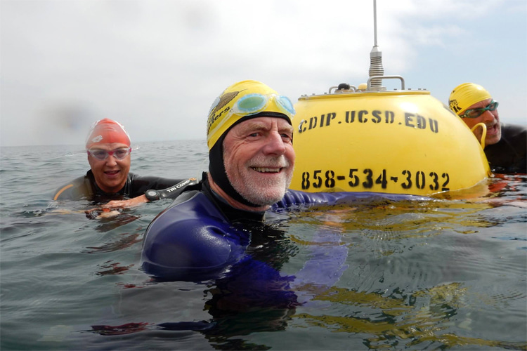
The most common model was the Datawell Waverider, a bright yellow sphere about 0.9 meters wide.
The design worked well. The Waverider could track waves with periods as short as 1.6 seconds, with no more than a three percent error.
That accuracy helped CDIP push farther offshore, beyond the reach of cables and land stations.
By the 1980s, CDIP instruments were spreading to new locations. Then came a major shift in the 1990s. Directional buoys entered the scene.
These new buoys did more than bounce with the waves. They measured wave direction, wave energy, and sea surface temperature.
Using sensors that tracked heave, pitch, and roll, they could map how waves moved across the ocean. Horizontal accelerometers measured motion north to south and east to west.
The result was cleaner data and a better signal.
Directional Waverider buoys soon became CDIP’s main tool. Like earlier models, they measured waves from 1.6 to 30 seconds in period, still within a three percent error.
A temperature sensor sat near the base of the buoy, about 45 centimeters below the surface.
Each buoy also carried a safety light that flashed five times every 20 seconds, following international standards.

Real Time Surf Data
The 1990s brought another leap.
By the late part of the decade, CDIP was collecting data continuously at about one sample per second. In 1996, the program put its data online in real time.
For the first time, surfers, mariners, and forecasters could see live wave conditions on the internet.
CDIP swell models quickly became a favorite.
Leadership evolved as the program grew. Seymour led CDIP until 2018. Meredith Sessions, David Castel, Robert Guza, William O’Reilly, and Julianna Thomas all played key roles over the decades.
Today, the program is led by principal investigator Eric Terrill, with James Behrens serving as co-principal investigator and program manager.
CDIP operates within Scripps’ Integrative Oceanography Division.
By 2017, CDIP had deployed and maintained wave stations at 271 locations across the western hemisphere.
Most sit along the U.S. Pacific and Atlantic coasts. Others watch the waves in the Great Lakes, Hawaii, Guam, the Gulf of Mexico, and even Brazil.
Some sites also measure wind, air pressure, and temperatures in the water and air.
Technology kept improving.
Nearly all CDIP buoys now send data through Iridium satellites, cutting the need for shore stations and allowing placements farther offshore.
Solar cells and large capacitors extend battery life. New hulls made from a metal alloy called Cunifer10 resist corrosion.
Together, these upgrades doubled or even tripled the time between maintenance visits.
State-of-the-Art Devices
The latest step forward is the Datawell Waverider 4 buoy.
It samples motion twice as fast as earlier models and measures wave height with an accuracy of about half a percent. It also measures surface currents using acoustic sensors built into the hull.
For crews deploying and servicing them, the buoys are tougher, lighter, and easier to handle.
Maintenance still matters.
Every two to three years, buoys are swapped out for freshly calibrated ones with new batteries. CDIP staff often dive to inspect moorings and sensors. Years can pass with steady data flowing in between visits.
Today, CDIP data streams to thousands of users every hour through its website and partnerships with NOAA.
Harbor masters, lifeguards, engineers, surfers, and boaters all check the same numbers brought to us by the bright yellow buoys, which turn ocean motion into valuable knowledge.
Real-time observations of the deployed surf buoys are available on CDIP’s official website.
Words by Luís MP | Founder of SurferToday.com
Leave a Reply